
For a robot to move safely and intelligently, it must understand where it is, what is around it, and how the environment is changing. This is where depth sensing cameras and LiDAR become essential.
Depth cameras provide close-range 3D perception and visual context. LiDAR provides accurate distance measurement, reliable geometric mapping, and, in some cases, longer-range detection. Together, these sensors help robots build maps, avoid obstacles, localize themselves, and make better navigation decisions.
MorpheusTEK provides camera and LiDAR solutions for robotics, warehouse automation, industrial vehicles, inspection systems, and autonomous platforms.
How depth sensing cameras help in 3D mapping
3D mapping is a core capability for many advanced robotic systems. It allows machines to understand their environment, plan movement, identify obstacles, and interact with objects in a spatially aware way. Depth sensing cameras play an important role in this process by capturing distance information and transforming it into usable three-dimensional data.
Accurate spatial awareness
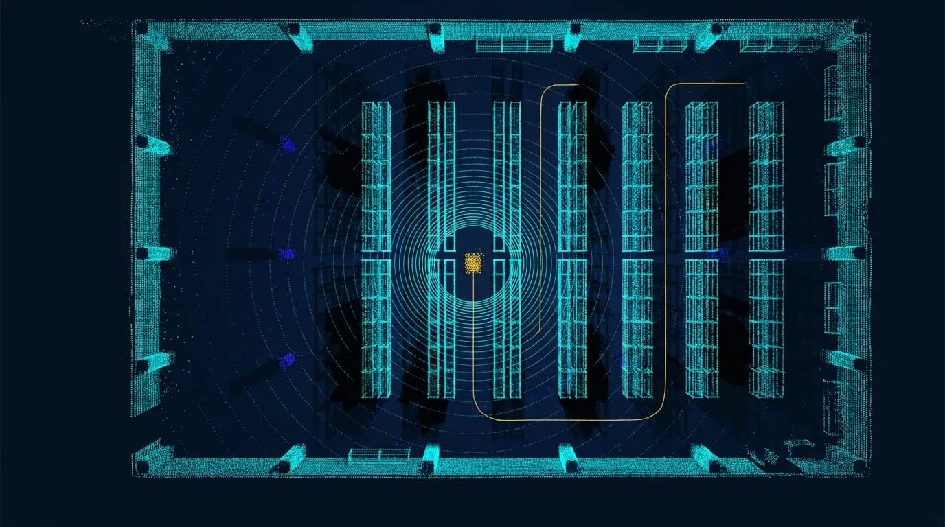
Depth sensing cameras generate real-time depth maps by measuring the distance between the sensor and surrounding objects. This data allows robots to create 3D point clouds — sets of points representing surfaces, objects, structures, and open space. These point clouds help robots understand:
- Object size and shape
- Distance to obstacles
- Free space
- Surface geometry
- Relative position of people, pallets, racks, bins, or machinery
This spatial awareness is critical for robots operating in warehouses, factories, fulfillment centers, hospitals, labs, and other dynamic environments.
Supporting SLAM and robot localization
Many robotic systems rely on SLAM, or Simultaneous Localization and Mapping, to build a map. Depth sensing cameras provide useful 3D input for SLAM by helping the robot identify surfaces, structures, and movement through space. Camera-based SLAM can be especially valuable in environments where visual features, color data, or close-range spatial detail are important.
LiDAR is also widely used for SLAM because it provides accurate geometric distance measurements. For example, a warehouse AMR may use a 2D LiDAR for navigation and localization, while also using a depth camera for pallet detection, shelf interaction, docking, or close-range obstacle awareness.
In more advanced systems, 3D LiDAR can support higher-resolution mapping of complex environments such as:
- Loading docks
- Outdoor yards
- Mines
- Ports
- Construction sites
- Large industrial facilities
Enabling detailed environment reconstruction
Beyond navigation, depth cameras can support detailed environment reconstruction for inspection, quality control, measurement, and digital twin applications. Robots equipped with depth cameras can scan objects, racks, workcells, bins, packages, or surfaces to detect changes over time.
For higher-range or larger-scale reconstruction, LiDAR can also be used to create dense 3D maps of facilities, substations, industrial sites, or outdoor environments. In some cases, a robotic system may combine LiDAR for overall structure and camera-based depth sensing for close-up detail.
Supporting dynamic and unstructured environments
Depth sensing cameras are especially valuable in environments where objects move, people enter the workspace, or obstacles appear unexpectedly. Continuous 3D data allows robots to update their understanding in real time and adjust their path or behavior. Examples include:
- A warehouse AMR detecting a person stepping into its path
- A robotic arm identifying a shifted part in a bin
- An autonomous forklift detecting pallet position
- A service robot avoiding carts, furniture, or people
- An outdoor robot adapting to terrain or unexpected obstacles
When paired with LiDAR, robots can gain both close-range depth detail and longer-range spatial awareness.
LiDAR as a complementary 3D perception technology
LiDAR is not a camera, but it is one of the most important 3D perception technologies in robotics. LiDAR sensors emit laser pulses and measure the return signal to generate accurate distance measurements and 2D or 3D point clouds. In robotics, LiDAR is commonly used for:
- AMR and AGV navigation
- Obstacle detection
- SLAM and mapping
- Safety zone monitoring
- Outdoor autonomy
- Long-range object detection
- Industrial vehicle awareness
- Low-light operation
For many applications, depth sensing cameras and LiDAR are complementary. A depth camera may provide high-resolution close-range 3D information and RGB data, while LiDAR may provide longer-range detection, robust geometric mapping, or safety-rated protective fields.
Camera-LiDAR fusion for autonomous navigation
In advanced robotics, combining depth cameras with LiDAR can create a more complete perception system. Each sensor contributes different strengths.
What LiDAR contributes
- Range & geometry
- Accurate range measurement and strong geometric mapping
- Data type
- 2D or 3D point cloud data
- Detection
- Long-range obstacle detection
- Conditions
- Low-light performance and SLAM support
- Safety
- Safety scanner options in certified systems
What depth cameras contribute
- Range & geometry
- Close-range 3D detail and object shape
- Data type
- RGB color information alongside depth
- Detection
- Human and object recognition support
- Conditions
- Compact integration · AI-ready visual data
- Safety
- Surface and shape detail for inspection
A common robotics architecture may use LiDAR for navigation and mapping, while depth cameras support object detection, manipulation, docking, pallet detection, or human interaction.
Navigation and obstacle avoidance
One of the most important functions for autonomous robots is safe and efficient navigation. Depth sensing cameras provided by MorpheusTEK can help AGVs, AMRs, autonomous forklifts, and service robots detect obstacles, identify free space, and build real-time 3D awareness of their surroundings.
For example, a warehouse robot may use a depth camera to detect boxes, pallets, people, dock edges, or objects protruding into an aisle. A LiDAR sensor may also be used for:
- Longer-range navigation
- 2D safety fields
- SLAM-based localization
- Obstacle detection around the robot base
- Mapping fixed structures such as walls, racks, and machinery
Together, cameras and LiDAR can provide a stronger perception stack than either sensor alone.
Choosing the right sensor stack for navigation
Indoor AMRs
A combination of 2D LiDAR and depth cameras may support reliable navigation, obstacle detection, docking, and pallet interaction.
Autonomous forklifts
LiDAR can support navigation and safety zones, while depth cameras help identify pallet pockets, load position, and nearby objects.
Outdoor robots
Ruggedized stereo cameras, 3D LiDAR, radar, and IMUs may be needed for longer-range perception, terrain handling, and changing weather.
Safety-rated applications
Certified safety LiDAR or safety scanners should be evaluated separately from standard perception cameras.
Depth sensing cameras and LiDAR are powerful tools for robot navigation, mapping, and obstacle avoidance. Depth cameras provide rich close-range 3D information and visual context. LiDAR provides accurate geometric distance data and strong mapping capability. When used together, they help robots operate with greater confidence in complex and changing environments.